If your property was destroyed tonight, could you prove what was inside?
Insurance companies only pay for what you can prove. Our clients who lost homes to fire got fully compensated because one 3D scan captured every room, every fixture, every item before disaster struck.
70%
Claims Underpaid
Exposed to losing 70% or more of your contents coverage when you can’t prove what you owned. No photos. No inventory. No payout.
$340K
Left on the Table
The average gap between what homeowners claim and what they recover without visual proof. Insurance companies are only required to pay what you can document.
1
Visit. That’s It.
One scan captures every room, every fixture, every item. No return trips. No missed measurements. Complete proof, ready before you ever need it.
One Visit. Every Measurement. Zero Guesswork.
We Scan
Our LIDAR-equipped Matterport cameras capture every surface of the property in full 360°. Every room. Every angle. Every inch.
We Measure
The scan generates precise dimensions automatically: wall lengths, ceiling heights, window sizes, countertops, built-ins. Accurate to the inch.
We Deliver
You get a fully navigable 3D walkthrough, a complete dimensional sketch, and court-admissible proof of every item in your property.
Don’t Take Our Word For It. Walk Through It.
This is a real 3D Assist scan. Click and drag to explore. Zoom in on fixtures. Walk room to room. This is the proof that protects you.
Loading 3D scan...
3D scan demo will appear here
Set NEXT_PUBLIC_MATTERPORT_URL to enable
Tap and drag to explore the 3D scan
Every surface. Every dimension. From any device, anytime.
Here’s What One Visit Gets You
Matterport 3D Walkthrough
Full 360° interactive model of your property. Every room. Every angle. Accessible from anywhere, anytime. No re-inspections, ever.
LIDAR Floor Plans & Sketches
Complete dimensional data: every wall, window, door, and built-in measured to the inch. Exports directly into Xactimate.
FAA-Certified Drone Photography
Aerial documentation for properties too damaged, toxic, or dangerous to walk. Full exterior coverage. Burn zones. Collapsed structures. Rooflines.
Hosted Digital Twin
Your scan lives on our servers. Access it anytime. Share it with attorneys, adjusters, or clients via a simple link.
All of this. One visit.
Built for the People Who Need It Most
Protect Everything You Own Before It’s Too Late
Our clients lost their homes to fire. Every single one got fully compensated because they had a 3D scan proving what was inside. Without proof, your insurance company is only required to pay 30% of your contents coverage. One scan. Complete protection. Before you ever need it.
See the Work. Judge for Yourself.
Real scans. Real properties. Real drone footage from active inspections across Southern California.
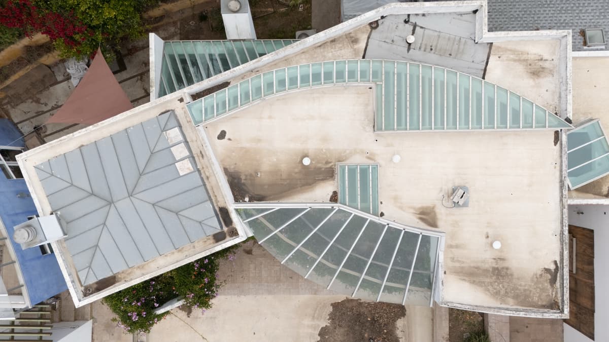
Aerial Property Survey
FAA-certified drone photography captures the full scope of a property: rooflines, lot boundaries, and structural damage invisible from the ground.
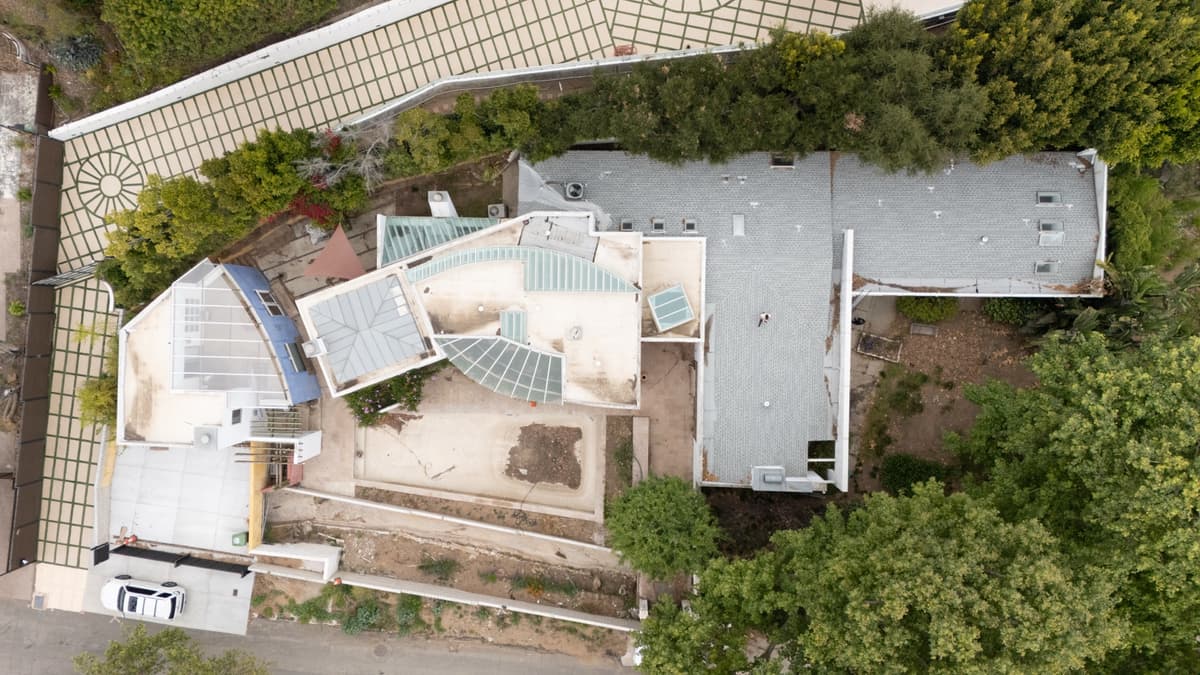
Overhead Documentation
High-resolution aerial shots provide adjusters, attorneys, and contractors with perspectives that manual inspection simply cannot capture.
Live Drone Inspection
Watch an active inspection in progress. Our FAA Part 107 certified pilot captures complete aerial documentation in a single flight.
Commercial. Architecture. Engineering.
Same scan. Different deliverables. Whatever the project needs, the data is already captured.
Commercial
Document Every Square Foot. Once.
Office, retail, industrial, multifamily, hospitality. One scan replaces every future site visit — leasing, renovations, insurance, due diligence, facility management. Hosted online forever. Accessible from any device, by anyone you give the link to.
Architecture
As-Built Drawings Without the Tape Measure.
Skip the measure-up. Get a LIDAR-accurate point cloud and dimensional sketch ready to drop into Revit, AutoCAD, or SketchUp. Existing-condition documentation captured in one site visit. No return trips. No missed walls.
Engineering
Survey-Grade Geometry. No Survey Crew.
Structural, civil, MEP. Accurate as-built geometry for retrofits, additions, and inspections. Pair the interior scan with FAA-certified drone aerials for complete site, roof, and exterior documentation. One vendor. One visit.
Built by Insurance Pros Who Saw the Problem Firsthand
Jared Boergadine spent years as a public insurance adjuster watching the same problem repeat on every claim. Missed measurements. Delayed re-inspections. Clients losing hundreds of thousands because nobody could prove what was in the home before it burned.
He started 3D Assist to fix it.
Using Matterport cameras equipped with LIDAR, his team captures every inch of a property in one visit and turns that data into the documentation that wins claims.
Built to serve his own firm, VIP Claim Service, 3D Assist now works with homeowners, contractors, attorneys, and adjusters across Southern California. And we’re just getting started.

Jared Boergadine
President & Founder

Danius Carauskas
Matterport Photographer & FAA Part 107 Certified Drone Pilot

Thomas
Lead Estimator & Xactimate Expert

Ingrid
Admin
The Proof Speaks for Itself
Multiple clients who lost their homes to fire were able to recover full compensation because their 3D Assist scans documented everything before disaster struck. That’s not a sales pitch. That’s what happened.
- Ask us for references from current clients
Don’t Wait Until It’s Too Late
One call. One visit. Complete proof of everything you own.
Or reach out directly:
(323) 250-6430
Tap to call
info@3dassist.net
Tap to email
@3DAssist
Follow on Instagram